Uttarakhand’s Joshimath has always been a historical and iconic destination to explore. This destination is one of the places that Hindu devotees dream to visit. Unfortunately, the town is on the brink of collapse and is making headlines for the past some days for this reason. The town is sinking down and the residents are extremely tense about what will happen now. Indian Space Research Organisation has shared some pictures recently that clearly show the land subsidence.
ISRO’s Latest Shared Satellite Images Of Joshimath
The recent satellite images of ISRO clearly show the differences between the town in the past and how much it has sunk recently. The problem with land subsidence is clearly visible. Geologist Harsh Vats took to his Twitter handle to share the satellite images and you can take a look at them here.
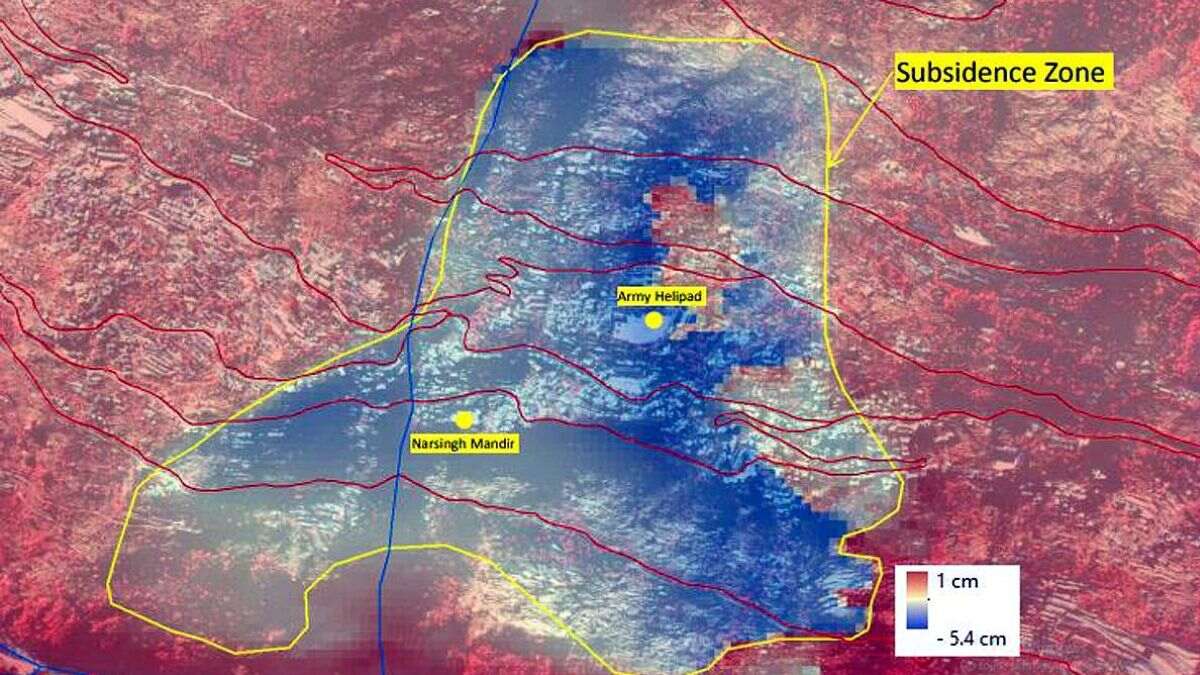
According to a preliminary observation by ISRO, the entire town of #Joshimath might sink as a result of rapid land subsidence. The holy town sank 5.4 cm in a period of just 12 days! Central part of Joshimath town, army helipad and Narsingh Mandir are witnessing rapid subsidence. pic.twitter.com/qEvqRAFID8
— Harsh Vats (@HarshVatsa7) January 12, 2023
The report states that Joshimath “might sink as a result of rapid land subsidence”. The Uttarakhand town has already sunk 5.4 cm in just 12 days. Place such as the army helipad, the central part of the town, and the Narsingh Mandir are experiencing the most horrific land subsidence.
Also read: Uttarakhand’s Joshimath Is Sinking, PM Modi Calls For A High-Level Meeting
Sentinel-1 SAR imagery (Descending pass) was processed using the DInSAR technique to identify the possible location and extent of land subsidence in long and short time intervals. Slow subsidence up to ~ -9 cm within Joshimath town is recorded, between April and November 2022. pic.twitter.com/2yZoQReSPC
— Harsh Vats (@HarshVatsa7) January 12, 2023
The report also states that Joshimath experienced slow land subsidence in the time period between April and November 2022. This town sank 8.9 cm during this phase. The DInSAR technique has been used for examining the area and intensity of land subsidence in Joshimath.
Between 27th December 2022 and 8th January 2023, a rapid subsidence event was triggered. The region subsided around ~ -5.4 cm within a span of 12 days and the areal extent of subsidence had also increased. #JoshimathIsSinking pic.twitter.com/6jqefXrwUH
— Harsh Vats (@HarshVatsa7) January 12, 2023
The intensity increased from 27 December to 8 January when it sunk by 5.4 cm in just 12 days. In fact, the areal extent of land subsidence in Joshimath had also increased.
More Updates From The Latest Images Shared By ISRO
The new Cartosat-2S satellite has been used for capturing these ISRO satellite images.
The identified subsidence zone was correlated with new Cartosat – 2S satellite data acquired by ISRO
on 07th and 10th Jan 2023 (fig. 1). A Digital Elevation Model of Joshimath town: pic.twitter.com/mEnbatonoW— Harsh Vats (@HarshVatsa7) January 12, 2023
One of these images spotted a subsidence zone that resembles a shape of a landslide. The crown of this zone is at an elevation of about 2180 metre near the Joshimath-Auli road. In fact, the photos show that this road is on the verge of destruction as a consequence of subsidence.
Also read: Joshimath In Uttarakhand Is Sinking! Here’s Why.
The situation is worsening every day making the locals petrified. The Uttarakhand High Court has already asked the Uttarakhand government to make a plan for Joshimath.
Cover Image Courtesy: Twitter/ Harsh Vats (@HarshVatsa7)
First Published: January 13, 2023 11:26 AM


